[May 2023] Dr. Tong Li completes his PhD research visit in our lab

Tong Li came a year ago as a visiting PhD student. This month he completed his PhD, defended his thesis and went back home after a fruitful year of collaboration. Tong brought lots of insights and knowledge about the integration of geostatistical techniques and deep learning. We hope to continue our collaboration!

In the picture below, from left to right: Noble Potakey (M.A.Sc. student), Dr. Julian M. Ortiz (Lab director), Soheil Kheirparast (M.A.Sc. student), Dr. Tong Li (visiting Ph.D. student), Seyda Nur Yildirim (M.A.Sc. student), and Dr. Sebastian Avalos (Research Associate).

[Nov 2021] Paper on uncertainty quantification at any volume without geostatistical simulation

The paper “Uncertainty Assessment over any Volume without Simulation: Revisiting Multi-Gaussian Kriging” by Alvaro I. Riquelme and Julian M. Ortiz was recently published in Mathematical Geosciences, Vol 53, pages 1375-1405. The paper provides a method to assess the uncertainty of any volume without simulation. This can be used to transfer spatial uncertainty downstream in a mining complex.

The abstract is:

Assessing spatial uncertainty over an arbitrary volume is usually done by generating multiple simulations of the random function and averaging the property over each realization to build its uncertainty distribution. However, this is a cumbersome process for practitioners, as they need to compute and process a large number of realizations. Multi-Gaussian kriging provides a simpler alternative, by directly computing the conditional probability density functions of the random variables. In this work, we revisit the multi-Gaussian framework and present the implementation details to determine the conditional distribution at any support, by numerical integration of the conditional probabilities, using an importance sampling approach. We demonstrate the use of this approach and assess its accuracy in the lognormal and exponential cases with synthetic data. We also apply it to a real three-dimensional mining case, where the uncertainty over scheduled production volumes is determined. The ability to assess this uncertainty may prove valuable, as it enables schedule changes to be made in a mining setting in order to ensure the smooth running of downstream processes.

The paper can be found here: Uncertainty Assessment over any Volume without Simulation: Revisiting Multi-Gaussian Kriging | SpringerLink

[Oct 2021] Sebastian Avalos awarded SFU Beedie i2I Skills Training

In a competitive application process, Sebastian was selected to complete the SFU Beedie i2I Skills Training in partnership with Mitacs.

The Invention to Innovation (i2I) Skills Training helps developing entrepreneurial mindset in scientists and engineers. The program has a duration of 7 months and concludes with a live Final Pitch Event.

Congratulations Sebastian!

[Oct 2021] New paper on Mineral Resource Classification with Machine Learning

The paper “On the use of machine learning for mineral resource classification” by Ilkay S. Cevik, Oy Leuangthong, Antoine Cate and Julian M. Ortiz was recently published in Mining, Metallurgy and Exploration, Vol 38, pages 2055-2073. The paper was developed by proposes a methodology to perform mineral resource classification in a consistent and automated manner with a sequence of machine learning methods. This ensures a simple application that can be easily audited and that can be tuned by a Qualified Person, to ensure results are consistent with the uncertainty associated to the resources and the geology.

The methodology combines a repeated application of unsupervised random forest over subsets of blocks in the model, to determine a distance matrix, which is then clustered to discriminate between different classes of blocks. This is then used in a supervised application of random forest to classify the blocks and determine their probability of belonging to each class (measured, indicated and inferred). The method is demonstrated in real deposits, and compared with a Qualified Person classification done with conventional methods.

The paper can be found here: On the Use of Machine Learning for Mineral Resource Classification | SpringerLink

[Oct 2021] Mehmet Altinpinar completes M.A.Sc.

Mehmet successfully completed his M.A.Sc. in Mining Engineering. Mehmet defended on October 15, 2021, his thesis “Synthetic High Resolution Block Model for Benchmarking Mining Technologies“. His committee was formed by Prof. Takis Katsabanis and Prof. Qian Zhang, as examiners, Prof. Julian Ortiz as supervisor, and Prof. Asli Sari as cosupervisor. The exam was chaired by Prof. Christopher Pickles.

Congratulations Mehmet!

[Sep 2021] Sebastian Avalos completes Ph.D.

On August 25, 2021, Sebastian Avalos defended his Ph.D. entitled: “Advanced Predictive Methods Applied to Geometallurgical Modelling“. The examination committee consisted of Prof. Kamran Esmaeili (Mining Engineering, U. of Toronto), Prof. Xiaodan Zhu (Electrical and Computing Engineering, Queen’s University), Prof. Asli Sari (Mining Engineering, Queen’s University), the co-supervisor Prof. Willy Kracht (Mining Engineering, Universidad de Chile) and the supervisor Prof. Julian Ortiz (Mining Enginering, Queen’s University). Prof. Takis Katsabanis was the Chair of the examination committee (Mining Engineering, Queen’s University).

Congratulations!!

[Apr 2021] New paper about a data-driven definition of geological domains with domain knowledge

Fouad Faraj spent a summer as a graduate intern. During these months he developed an idea to apply a statistical based multivariate approach to define geological domains. The main idea is to first split the global distribution of multiple attributes (geochemical concentrations) into sub-populations that follow a parametric distribution. This leads to an optimization problem to fit these distributions. Then, every sample in the database can be allocated into one of the sub-populations, initially at random, and then samples belonging to different domains are swapped with a greedy algorithm, to reduce the MSE over the expected distribution. Amazingly, this leads to consistent spatial clusters. Domain knowledge is input during the selection of the discriminant attributes used in the first step. Theoretically this could be extended to many variables, although, as usual, a good fit of the resulting distributions would require a large number of samples (and the computational cost would increase significantly).

The full paper can be downloaded here: https://doi.org/10.1007/s42461-021-00428-5

For a limited time, the paper can be read here: https://rdcu.be/ciQlU

A Simple Unsupervised Classification Workflow for Defining Geological Domains Using Multivariate Data

by Fouad Faraj & Julian M. Ortiz

Abstract

Within the natural resource industries, there is an increasing amount of data and number of variables being recorded when sampling a site. This has made multivariate geospatial datasets more difficult to analyze, in particular the definition of estimation or simulation domains used in geostatistical analysis. Establishing these domains is typically the first step for any subsequent geostatistical workflows or modeling. Domains are traditionally established using categorical data such as lithology, mineralization, or alteration from geological logging and are aimed at identifying distinct populations with particular geological, spatial, and statistical features. The manual logging process is time-consuming and costly but is required because defining geologically homogenous volumes is crucial for the planning, extraction, and processing of natural resources. Classical clustering methods have aided in analyzing the multivariate datasets, but the resulting clusters from these methods do not correlate well with geological logging and do not allow practitioners to input their knowledge of the domain in the clustering process. In this work, a simple unsupervised classification workflow is presented which allows the practitioner to input domain knowledge by selecting relevant variables to cluster reasonable geological domains. This can be used as a tool to aid the manual logging procedure or as a tool to establish domains for different uses such as defining zones with different rock hardness distributions which allows the corresponding volumes to be sent to appropriate mills for efficient mineral processing. The performance of the workflow is assessed on a mining dataset using the geochemical information and validated with the geological logging.

[Nov 2020] New paper in Natural Resources Research: Simulation of Synthetic Exploration and Geometallurgical Database of Porphyry Copper Deposits for Educational Purposes

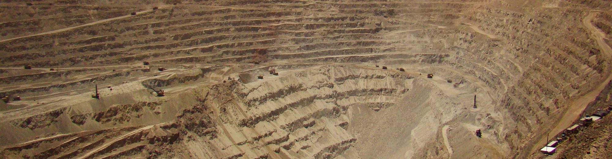
The December issue of Natural Resources Research features our paper “Simulation of Synthetic Exploration and Geometallurgical Database of Porphyry Copper Deposits for Educational Purposes” in collaboration with Mauricio Garrido (Ph.D. candidate in the Department of Geology at Universidad de Chile), who spent a short research internship in our lab. The paper is also coauthored by Dr. Exequiel Sepulveda (University of Adelaide) and Dr. Brian Townley (Universidad de Chile).

The paper can be downloaded here.

Simulation of Synthetic Exploration and Geometallurgical Database of Porphyry Copper Deposits for Educational Purposes

Mauricio Garrido (Department of Geology, Universidad de Chile), Exequiel Sepulveda (School of Civil, Environmental and Mining Engineering, The University of Adelaide), Julian Ortiz (The Robert M. Buchan Department of Mining, Queen’s University), and Brian Townley (Department of Geology, Universidad de Chile)

Abstract

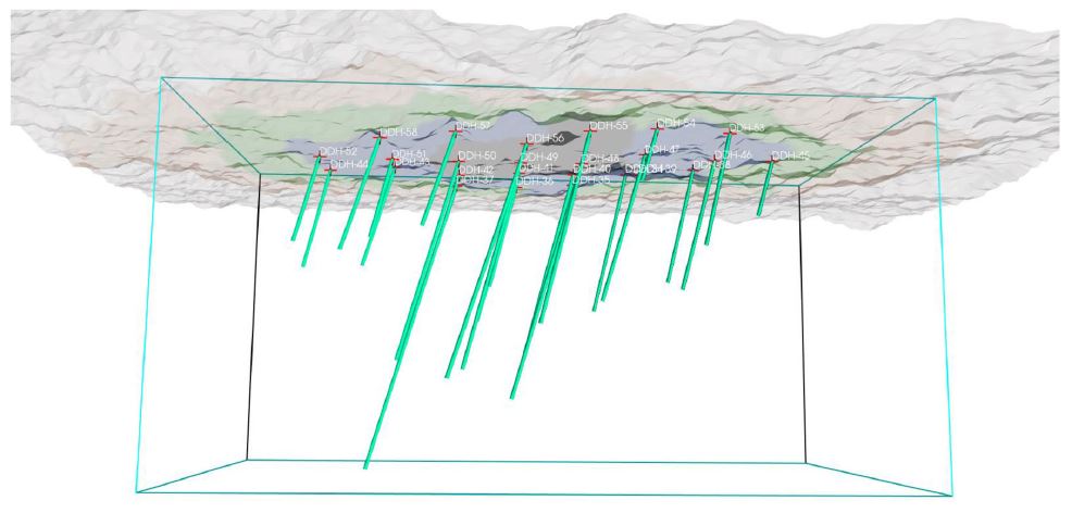
The access to real geometallurgical data is very limited in practice, making it difficult for
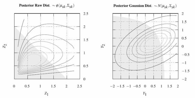
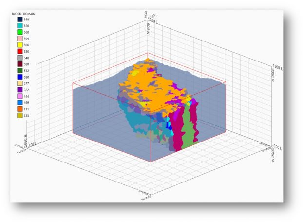
practitioners, researchers and students to test methods, models and reproduce results in the field of geometallurgy. The aim of this work is to propose a methodology to simulate geometallurgical data with geostatistical tools preserving the coherent relationship among primary attributes, such as grades and geological attributes, with mineralogy and some response attributes, for example, grindability, throughput, kinetic flotation performance and recovery. The methodology is based in three main components: (1) definition of spatial relationship between geometallurgical units, (2) cosimulation of regionalized variables with geometallurgical coherence and (3) simulation of georeferenced drill holes based on geometrical and operational constraints. The simulated geometallurgical drill holes generated look very realistic, and they are consistent with the input statistics, coherent in terms of geology and mineralogy and produce realistic processing metallurgical performance responses.
These simulations can be used for several purposes, for example, benchmarking
geometallurgical modeling methods and mine planning optimization solvers, or performing risk assessment under different blending schemes. Generated datasets are available in a public repository.